III. 2MASS Facilities and Operations
2. Data Acquisition
c. Sky Coverage
70,712 scans were made in photometric conditions during 2MASS Survey operations. Among these were one or more scans of each of the 59,650 Survey Tiles (see III.2b) and 325 scans of special "gap-fill" Tiles. 2MASS survey Tiles overlap each other by 10% (51´´) in right ascension on the equator-most ends, and by 8.5´ in declination on both ends. Small telescope pointing errors occasionally caused Survey scans to miss the nominal position of the Tiles. As a result, sky coverage gaps could be left between Tiles. The presence of gaps was monitored throughout the Survey, and "gap-fill" scans were scheduled to fill missed coverages.
i. Physical Gaps
At the completion of Survey operations, 21 separate gaps remained unfilled, because of weather conditions and schedule constraints. The approximate central equatorial position of each gap is listed in Table 1. Linked to each row in the table in the "Vertices" column is a listing that gives the vertices in equatorial coordinates of the polygon gap regions. The total area enclosed by these gaps is 0.644 deg2 (0.002% of the sky). There are no Atlas Image or Catalog data available in these regions.
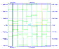
The IRSA/2MASS Image Services display the outlines of the physical gap areas in red, when a position near a gap is specified in the "Close-up Map" mode. Figure 1 shows the "close-up map" coverage chart for 16h52m13.20s +18d00m55.7s (J2000), which is centered on gap 16 (Table 1) and is near gap 17. The outline of the Atlas Images in this area are shown in green.
Table 1 - 2MASS Physical Coverage Gaps
ii. Effective Gaps
In addition to the 21 physical coverage gaps, the All-Sky PSC and XSC contain effective gaps in coverage. Sources extracted from the 2MASS scan data are required to be >10´´ and >15´´ from the edges of Tiles to be included in the PSC and XSC, respectively (cf. V.3.a). Effective gaps occur when there is not sufficient overlap between scans of adjacent Tiles to accommodate these edge boundaries. If the overlap between adjacent Tiles is < 20´´ at any point, there will be an effective coverage gap in the PSC. Similarly, overlaps < 30´´ will result in effective coverage gaps in the XSC. Needless to say, the Tiles with real gaps between them will have even larger associated effective gaps, and all of the PSC effective gaps areas will produce XSC effective gaps. There may be Atlas Image coverage of the Catalog effective gap areas.
There are 43 effective gaps in the PSC, including the areas of the physical gaps. They enclose a total area of 1.152 deg2, or 0.003% of the sky. The central position of each of these gaps, and links to the vertices of the polygon gap areas are listed in Table 2.
The XSC contains 88 effective gaps, enclosing a total area of 1.482 deg2, or 0.004% of the sky. The central position of each of the XSC effective gaps, and links to the vertices of the polygon gap areas are listed in Table 3.
Table 2 - 2MASS PSC Effective Coverage Gaps
Table 3 - 2MASS XSC Effective Coverage Gaps

|
| Figure 1 |
[Last Update: 2003 March 3, by R. Cutri, D. Kirkpatrick & L. Cambresy]
Previous page. Next page.
Return to Explanatory Supplement TOC Page.